History of Tonbridge
- Introduction
- Tonbridge Timeline
- Events
- People
- Places
- Pictures - pre-1950
- Pictures - 1963-80
- How Tonbridge has grown
- From the archives
- Made in Tonbridge
- Miscellany
- Links

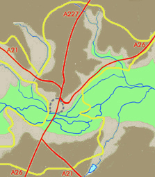
Contour map showing how the first settlement (dashed outline) developed where higher ground intrudes into the flood plain (green). Pre-bypass main roads are in red. The yellow line outlines the present built-up area.
Like many towns, Tonbridge owes its existence to the local geography. In this part of Kent the river Medway has always been a barrier to north-south movement. It flows in a wide marshy plain that falls only gently from west to east, making it liable to frequent flooding. But a spur of harder ground juts down from the north at a point where there is also high ground – Quarry Hill – to the south. It is at this natural crossing-point, where the flood plain narrows to less than a mile in width, that Tonbridge has grown up.
Few prehistoric remains have been found in the Tonbridge area, and there is no evidence of any settlement here. But the river crossing provided the shortest track between the Iron Age forts on Oldbury Hill (near Ightham) and Castle Hill (west of the A21 between Tonbridge and Pembury). The ancient trackway has been traced running along the east side of the present Shipbourne Road, and there is evidence the Romans improved it to serve their Wealden iron industry.
In time the strategic importance of the river crossing made it part of a main route from London to Rye, Hastings and the continent. But the surrounding area was one of densely forested Wealden clay and it was therefore settled relatively late. There may well have been a small settlement beside the river, and possibly even a bridge, in Saxon times, but there is no firm evidence.
In fact there is only scant information until Domesday Book in 1086. Even here, because Tonbridge and its surroundings formed an exceptional area – a 'lowy' granted by William the Conqueror to one of his most trusted companions – it was exempt from the need to provide details to the Crown. Domesday simply records that 'Richard of Tonbridge' held the adjoining manor of Hadlow and elsewhere we learn that Richard attended a muster on Penenden Heath in 1070. In the 11th century a castle was built overlooking the river, providing both haven and custom for those living nearby.
By 1100 Tonbridge had become a busy settlement and the centre of a huge parish of more than 15,000 acres, the largest in Kent.

Conjectural bird's-eye looking south over Tonbridge as it might have looked in c.1260. (THS1.012det. From a drawing by J. F. Wadmore, 1886)
Essentially the heart of the early town lay to the north of the river, from the present Big Bridge up to the Ivy House. This area was so well established by 1259 that the Clare family, who had occupied it since the Conquest, obtained a licence to surround it with a wall. Nothing, however, was achieved other than a defensive ditch – the Fosse – traces of which still remain. South of the river the only permanent settlement was the Priory of St Mary Magdalene, founded in the 12th century. This occupied a site east of the present railway station bridge.
By 1550 parish registers suggest that the population of the entire parish numbered about 1,200, some 500 of whom may have lived in the town itself. The town's facilities were much enhanced in 1553 when Sir Andrew Judde founded Tonbridge School, a development much appreciated by the townsfolk who had had little educational provision since Cardinal Wolsey suppressed the Priory in 1524.
By the mid-17th century, there was continuous development from the bridge to Bordyke, beyond which were some scattered houses in their own grounds. The only noteworthy settlement south of the. bridge, on ground liable to severe flooding, was Peach Hall which lay to the east of the present High Street. After the Civil War, which saw one or two armed skirmishes locally, the town assumed a more modem appearance with the building of a six yard wide paved road from the end of Church Lane to the river. However south of the bridge the thoroughfare to the main Hastings road still consisted of wooden clappers built up across land which was frequently flooded.

Sailing barges at Medway wharf (THS16.016)
Tonbridge really entered the modem age with the foundation of the Medway Navigation Company in 1740 which resulted in the building of wharves where goods could be unloaded from barges that came up the newly navigable river. Gunpowder and other naval supplies were despatched from the local powder mill and Wealden forest to the dockyard at Chatham. Financial and business interests rapidly expanded, making Tonbridge an increasingly prosperous small market town. Developments in transport and the new turnpike roads encouraged the growth of a flourishing coaching business based on the Rose and Crown Inn, from which there were regular connections to London, Maidstone, Brighton and elsewhere.
The 1851 census shows that Tonbridge was not only a busy market town but also a legal and medical centre for surrounding villages. There were employment opportunities in trades ranging from tailoring and shoe- and bonnet-making to heavier manufacturing such as the brickworks on Quarry Hill. The best known specialist craft was carried on by George Wise at his 'Tunbridge Ware Manufactory'. This well-known decorative wood technique originated in the town and the wide variety of boxes and trinket cases produced met a growing demand for more artistic items.
The railway link with London was opened in 1842. The new station was sited south of the river and so began to alter the shape of the town. Housing, firstly for railway builders and employees and then for regular travellers, was erected in the vicinity of Quarry Hill and Pembury Road.

Tonbridge Cricket Team, date unknown (THS31C.09)
By the 1930s Tonbridge was still a rural town with a cattle market and a separate Saturday market but it also had modem amusements including three cinemas, a skating rink and annual Venetian Fêtes on the river. The extensive Sports Ground had replaced the old Race Course where at the turn of the century horse races had been very popular. No sport however was more popular in Tonbridge than cricket. For many years the Angel Ground was the Nursery of Kent cricket, a claim to fame which was sadly ended by World War II.
With the changing needs of recent years much has altered. A commuter town has evolved and housing developments in the north and south ends of the town since the 1960s have given it its present dumb-bell shape. With the erection of the flood barrier after the disastrous floods of 1968 even the middle of the area is now taking on new life. Nevertheless it is still just possible to recognise the description given in Pigot's Directory of Kent in 1824: 'It has one principal street which is capacious and neat. Here are many excellent shops, and the inns present every necessary accommodation.’